

Pogoniani (formerly Vostina) is located in the northwestern part of Ioannina Prefecture, along the border between Greece and Albania. It is built on the eastern slopes of Mount Bozovo at an altitude of 740 meters.
According to Spyros Stoupis, Pogoniani was the second hub of Pogoni, serving as the administrative center during the Ottoman period and as a commercial center for the western part of the region.
Around the late 1800s, it was divided into main Vostina and Varos, where a renowned tekke (Muslim monastery of dervishes) was located. It had a grand church, a mosque, an administrative center, schools for both Muslims and Greek Orthodox, three inns, and five shops. It also operated a Public Gymnasium and a National Boarding School.

Pogoni is one of the lesser-known areas of Epirus. For many years, it endured “political” isolation from the state, which affected it for decades. However, the long-standing history of these villages enables them to continue their traditions despite the passage of time.

Historical Facts and Information about Pogoniani
Historical Origin of Pogoniani and the First Settlements Around the Area:
There are no precise historical records regarding the initial settlement of Pogoniani. However, according to oral tradition, the first inhabitants of Pogoniani, as well as Dolo, were families of farmers and shepherds from Macedonia. Between 1030 and 1100, seeking a safe location and trying to escape barbarian invasions, they moved to and settled in the area.


Over time, the settlers spread throughout the area surrounding Pogoniani.

According to the book Dolo in Pogoni, most families settled collectively at the southern point of the “Megali Rachi” and below, forming four settlements: Avles, Omala (or Omali), Tourovo, and Kopanos. These settlements were established close to one another for security reasons.
It is likely that families from Turnovo (now Gorgopotamos) in the province of Konitsa came to Tourovo. They originally arrived as craftsmen (builders) from their village and settled permanently, naming the settlement Turnovo, later Tourovo (now Tourovo Forest), in memory of their homeland. These settlements remained until the 14th or even 15th century.
The area of the four settlements served as a passage point because a branch of the Egnatia Road passed through, following a long route through Pogoni and along rivers, with connections to Gjirokastra, Delvinë, Saranda, Brindisi, and Rome.

In this area, they had built two churches to meet their religious needs, remnants of whose foundations were found among the oak trees. Serbian families likely settled alongside the first inhabitants in Vostina and remained until the arrival of the Turks (1450-1500), at which point they were forced to leave the area.
However, during excavations in 1940, graves covered with slabs and oriented to the east, in accordance with Christian customs, were uncovered. The skeletons indicated that the buried individuals were tall in stature.

The dreadful disease that began in Italy appeared in Pogoni around 1343-1345 and literally decimated the population within a few years.
Two-thirds of the population died. Those who survived the plague moved northwest and established the settlement “Ziouglarates” (Ziouglarates means “farmers” and derives from the word ziougklines, a yoke attachment used to secure the necks of oxen). The surviving residents of Tourovo migrated to Bulgaria.
Vostina, as a distinct settlement, was likely formed after 1550. The first residents were Muslim converts from various regions, whom the Turks settled there.
According to tradition, around 500 Muslim families gathered in Vostina, attracted by the healthy climate, ample pastures, and Vostina’s position as a natural center for the 22 villages of the area. Over time, many of these families relocated to other areas. With the settlement of Muslim families in Vostina, the Turks seized Christian residents’ properties and transferred them to the converts, further restricting the Christians to a designated area and forcing them to relocate. The oppression they suffered led many to emigrate to other places.
To fulfill their religious duties, the converted families built a Muslim mosque and established dervishes (instructors) and Bektashis (monks, schismatic Muslims who revered the Prophet Elijah). A Bektashi tekke (monastery) was founded in Vostina, where dervishes and Bektashis lived, leading rather indulgent lives. Around this time, Turko-Gypsies also settled in the area, providing entertainment for the Turks during celebrations.
Source: Νίκος Θ. Υφαντής, Η Πωγωνιανή – Παλιά Βοστίνα και τα Κοινοτικά Διαμερίσματα Δολό – Δρυμάδες – Σταυροσκιάδι, σελίδα 101
There are several theories about the origin of the first name, Vostina, with the most prominent being:
- Lampridis interprets it as a “grazing place” due to the numerous pastures in the area.
- According to A. H. Papacharisis (Contribution to the Toponymy of Pogoni), the word Vostina in Serbian means “place of bees,” and on the slopes of the mountain above the village grows the bee herb.
- The most likely origin, however, is from the Turkish word bosti, meaning “place of tax payment.” Around 1550, the Turks required residents from the entire region to come to Vostina to pay their tax (bosti).
As for the name Pogoniani, according to Kostas Oikonomou (The Place Names of Ioannina Prefecture), the name appears in documents from the 16th-17th centuries in forms such as Pogoniani, Pogoiani, Pogoiani. The toponym originates from the adjective Pogoniani, with the omission of nouns like “location” or “church,” and it derives from the neutral Pogoni with the suffix -iani.
The name Pogoniani was generally applied to the entire Pogoni region. However, the community council of Vostina, which wished to adopt the region’s broader name, restricted the use of Pogoniani to a single community.
The form Pogoniani is also used in various local folk songs and holds the same breadth of meaning as the word Pogoni.
Today, the form Pogoniani is officially used only in the title of the Metropolitan: “Metropolitan of Pogoniani and Dryinoupolis, Exarch of all Northern Epirus.”
Source: Α.Χ. Παπαχαρίσης «Συμβολή εις το τοπωνυμικόν του Πωγωνίου» ΗΠΕΙΡΩΤΙΚΑ ΧΡΟΝΙΚΑ, 1933
The toponym Pogoni may be formed as follows:
- From the noun apogoni, meaning “the sheltered area,” and the adverb apougona, meaning “sheltered.”
- Or from the Slavic noun pogon, meaning “path,” combined with the prefix po (or pod), meaning “under, near,” and the noun gonb, meaning “pursuit, hunting ground, pasture, part of a field,” as well as the verb goniti, meaning “to hunt,” with the possessive adjectival suffix -jp, feminine -ja.
The Christian families that remained in Vostina numbered around 50 and lived scattered in huts, engaging in household livestock farming and agriculture. These families agreed to stay after the Turkish beys promised they would not be forced to convert to Islam.
Over time, most of them abandoned agricultural activities and began working in Turkish households as servants or laborers on estates. The remaining families (about 15) continued with agricultural work. These families were called “Tsiftji Hanedes,” and the people were referred to as tsiftjides. Gradually, Christians were allowed to build their huts on the edges of the estates.
Source: Νίκος Θ. Υφαντής, Η Πωγωνιανή – Παλιά Βοστίνα και τα Κοινοτικά Διαμερίσματα Δολό – Δρυμάδες – Σταυροσκιάδι, σελίδα 113
The policy of showing respect and willingness to work for the conqueror, even for minimal pay, was the only way for them to survive during a time when boys were forcibly conscripted into the Turkish army, and girls were violently taken from their homes to be placed in Turkish harems or given as gifts to Turkish officials. In this way, they managed to coexist and live while preserving their Christian names and maintaining—as much as possible—individual and family safety.
Because the Christians were obedient and disciplined, the Turks allowed them to build houses in the eastern part of the village. Much later, they built their first church, dedicated to Saint Nicholas, at the location where the main church of Pogoniani stands today.
Some of the beys protected the Christian population. One of them was Ismail Efendi. He came from Thessaly to Vostina, bringing as dowry two estates and maintaining mills by the river at the exit of the Kouvaras Gorge. When he arrived in Vostina, his original intent was to convert the Christians of the surrounding villages to Islam. However, instead of converting them, he ended up protecting them.
In Vostina, the Muslim population was the majority.
From 1560 onward, the area’s climate and location attracted many beys, who built grand residences with orchards—impressive in both size and wealth.
Today, Ismail Efendi’s summer residence, Bey of Thessaly, still stands, albeit in poor condition. This three-story building, located at the highest point of Vostina, was used as a Gymnasium Boarding School. Various alterations made to the building have destroyed its original interior layout.
Source: Νίκος Θ. Υφαντής, Η Πωγωνιανή – Παλιά Βοστίνα και τα Κοινοτικά Διαμερίσματα Δολό – Δρυμάδες – Σταυροσκιάδι, σελίδα 120
According to tradition, around 900 AD, Macedonians settled sporadically in various areas. They lived in clans led by the eldest, who served as the family’s leader. Excavations revealed collective cemeteries and isolated graves near remote and solitary residences.
The plague that struck in 1350 forced the inhabitants to gather in communal spaces, build houses, organize into communities, and integrate into a broader administrative system. The oldest and most experienced men formed the Demogerontia (Council of Elders) and made decisions on community matters.
After the Turkish conquest, the new administrative system favored the aghas and beys in collecting taxes from Christians. The responsibilities of the local leaders changed: some tried to serve the people and avoid the oppressions of the conquerors, others sought to avoid aiding the occupiers, while others, seeking personal gain, became Spahis (landed military officials).
Source: Νίκος Θ. Υφαντής, Η Πωγωνιανή – Παλιά Βοστίνα και τα Κοινοτικά Διαμερίσματα Δολό – Δρυμάδες – Σταυροσκιάδι, σελίδα 123
Social status played a primary role in all aspects of life—in church, festivals, celebrations, and family gatherings. Everyone had their place in the hierarchy: beys, aghas, landlords, nobles, bankers, and merchants, followed by others.
Of course, this order was not always consistent, and there were discrepancies within the hierarchy. The collection box and seats of the nobles saw changes in occupants.
Marriages were always arranged according to the same social class and religion.
Vostina was the center of 58 villages in the Vostina district. Village residents came to Vostina for various legal, administrative, and tax matters. For Christians, these gatherings also had national significance. Liberation was always their desire, and these meetings served as a way to organize.
Source: Νίκος Θ. Υφαντής, Η Πωγωνιανή – Παλιά Βοστίνα και τα Κοινοτικά Διαμερίσματα Δολό – Δρυμάδες – Σταυροσκιάδι, σελίδα 126
By decree of the Turkish government in 1846, Vostina’s market (Bazaar) was designated to be held every Thursday. This bazaar attracted agricultural and craft goods from 80 villages. It continued on a new basis from 1913 until 1940, when it ceased permanently.
Along with the shops, the old trades also disappeared: the tsaroucha makers, tailors and siegounades (wool coat makers), saddle makers, barbers, and many others. The khans (inns), which for years hosted caravans, closed down and were demolished. An old era faded away, leaving traces only in stories and old, faded photographs.
Browsing through Nikos Yfantis’ book Pogoniani – Old Vostina, we read that Pogoniani, before 1940 and before 1922 and liberation, had 34 various types of shops serving everyone.
Source: Νίκος Θ. Υφαντής, Η Πωγωνιανή – Παλιά Βοστίνα και τα Κοινοτικά Διαμερίσματα Δολό – Δρυμάδες – Σταυροσκιάδι, σελίδα 128
After the liberation struggles of 1912-13, the Albanian state was established, and Northern Epirus was incorporated into it. During this challenging period for Epirus—following the liberation struggles of 1912-13, the establishment of the Albanian state and its incorporation of Northern Epirus, the struggle for Northern Epirus’s autonomy, the delineation of Greek-Albanian borders, and the disaster of 1922—ways had to be found to protect orphans from Epirus and other regions of the “New Lands,” as well as refugee children from Northern Epirus and Asia Minor.
The solution came with the establishment of the Vostina Gymnasium. Within a few months, a four-year Gymnasium was founded in Vostina, beginning operations in the 1924-25 school year.
Despite the lack of resources, the work done at the Gymnasium, the students’ preparation at home, their training, and their acquisition of knowledge were remarkable. A large number of these students entered Higher Education without any special preparation and without any government support for housing and food.
Later, and for an extended period, thanks to the care of the Pogoni Philanthropic Association, a boarding house operated for all Gymnasium students for a symbolic fee. This boarding house was financially supported by the Ministry of Welfare and was housed in the so-called Annex, the largest Turkish building, located in a panoramic position near the foothills of Mount Bozovo. The building was named the Annex because it once served as an extension of the Orphanage.

Since 1963, the Gymnasium and Lyceum have been housed in a new building funded by financial contributions from the Pan-Pogonian Philanthropic Brotherhood of New York.
The Pogoniani Gymnasium lost its former influence as other Gymnasiums and Lyceums were established in the provinces of Pogoni, Zagori, and Konitsa, which drew in students. Additionally, after the 1940-41 war, the borders with Northern Epirus were permanently closed, leading to the depopulation of Pogoni villages and a lack of children.
Sources:
Νίκος Θ. Υφαντής, Η Πωγωνιανή – Παλιά Βοστίνα και τα Κοινοτικά Διαμερίσματα Δολό – Δρυμάδες – Σταυροσκιάδι, σελίδα 270
Επαμεινώνσας Βαδίλης, ΗΠΕΙΡΩΤΙΚΗ ΕΣΤΙΑ ΘΕΣΣΑΛΟΝΙΚΗΣ, ΕΤΟΣ ΣΤ΄, τεύχος 1, σελ. 11
The only systematically organized Student Residence was the so-called National Orphanage of Pogoniani, which still exists today. It accepted only orphaned students, providing them with everything they needed—housing, clothing, shoes, food, and all school supplies.


The Cultural Heritage of Pogoniani: Museums and Artistic Spaces
Folklore Museum of Pogoniani – Dropolis
The idea of establishing a Folklore Museum was born in the 1960s and was initially realized by temporarily housing it in the old Primary School. Later, it was moved to the mansion of Leonidas Vasiliadis, where it remained for several years.
The area was rich in traditional artifacts that were at risk of being lost. Efforts were made to gather and preserve this material, either through donations of family items from residents or by conducting searches, even in old buildings.

This resulted in a remarkable collection that includes local costumes, embroidery, household utensils, items from agricultural and pastoral life, tools, and much more.
The historical significance and cultural value of this museum, established in the border region, are immense.
After some years, the Community also granted the building that housed the military outpost, along with all the museum material, to the Phileducational, Folklore, and Cultural Association. The building was renovated under the Leader program of the European Communities and was suitably repaired to house the Folklore Museum.
On August 25, 1996 (twenty years after the museum’s initial inauguration), the museum was inaugurated in its new location, where it remains today.
Source: Νίκος Θ. Υφαντής, Η Πωγωνιανή – Παλιά Βοστίνα και τα Κοινοτικά Διαμερίσματα Δολό – Δρυμάδες – Σταυροσκιάδι, σελίδα 338
Pogoniani Postal and Telecommunications Museum, Pogoni
The museum was established in 2013, with its inauguration taking place on August 12, 2013. It is housed on the ground floor of the Kolefas building and serves as a museum and communication space.
The collection of items was gathered by individuals who worked at OTE and ELTA, each of whom contributed in their own way to the creation of this museum. The largest part of the collection belongs to Mr. Kostoulas, who founded the museum with the aim of contributing to the cultural heritage of the area.
Source: Βοστινιώτης
The “Mosaic Workshop and Art Exhibition of Yiannis and Nikos Kolefas”
It is housed in Pogoniani, in the Municipality of Pogoni, in a historic preserved building constructed in 1870. The building was previously used as an administrative center by the Turks.
In the 1950s and 1960s, the first floor of the building housed commercial shops, while the second floor accommodated the offices of the Pogoniani Association. In 2013, the Municipality of Pogoni approved a restoration study for the building as part of the “Rural Development of Greece 2007-2013” program, which was completed in 2016.
The restored building now meets all modern museum standards and is ready to host the permanent exhibition of works by Yiannis and Nikos Kolefas, as well as various educational museum programs focused on the art of mosaic.
The building belongs to the Municipality of Pogoni, while the collection is owned by the “Friends of the Mosaic Workshop and Art Exhibition of Yiannis and Nikos Kolefas.”
Source: Βοστινιώτης
Activities in the area
There are many routes for visitors to explore in both the nearby and wider area. One of the most beautiful is the visit to the two bridges in the Kouvaras Gorge.
The Kouvaras Gorge and the two stone bridges within it, spanning the river of the same name, are well worth a visit.
One of the most beautiful sights in the area is the Kouvaras Gorge and its two stone bridges.
Nonoulos bridge
Nonoulos bridge and the watermill are located at the beginning of the ravine and can be accessed by a cobblestone path starting from the paved road. Specifically, it is situated at the northern exit of the Kouvaras Gorge between Dolo and Pogoniani (Vostina) and spans the Kouvaras River at the location called Xylogefyro, where there once was a wooden bridge.

The bridge is a single-arched structure with a span of 7 meters and a height of 6 meters above the water’s surface. It was built in the late 19th century with the savings of Nonos (Nonoula) Galanou, a poor woman from Dolo. Traveling daily to Vostina with her donkey to sell wood, she risked her life crossing the decaying wooden bridge. So, she decided to have it built in stone.


There are two different accounts regarding whether Nonoula managed to fulfill her dream before or after her death.
- According to the first account, poor Nonoula saved up her money and eventually gathered enough to have the bridge built. However, one day while riding her donkey, the animal was startled and threw her to the ground. This fall may have been the cause of her passing.
- According to the second account, after Nonoula’s death, coins totaling 5,000–5,500 Turkish lira were found hidden in her house wall. With this money, the stone bridge was built in place of the wooden bridge in her memory.
Regardless of these accounts, her fellow villagers never forgot her.
Next to the bridge stands the old watermill, now renovated.
Source: ΣΠΥΡΟΣ ΜΑΝΤΑΣ, ΓΕΦΥΡΟΓΡΑΦΙΑ ΤΗΣ ΠΙΝΔΟΥ ΤΟΜΟΣ Γ΄, σελ. 84
Kouvaras bridge
The second bridge, known as the “bridge within the gorge,” can be accessed from the area “Tsoumpari” before reaching Dolo. The path is well-marked, completely safe, and requires about 15 minutes of easy walking to reach the Kouvaras riverbed and the bridge. Specifically, it is located below the village of Dolo, in the Pogoni region, deep within the Kouvaras Gorge at the location called Gouves.
It is a single-arched bridge crossing the river of the same name, and it once served the old path leading to Pogoniani (formerly Vostina). The bridge was constructed in 1927 by decision of the village council, following designs by an engineer from Ioannina.

The master builder Paschalis Zounis from Pyrsogianni worked on the bridge with his crew. The cost amounted to 16,000 drachmas, mainly funded by Dolo natives who had emigrated to America. The locals contributed with manual labor, and the women carried materials.
The bridge’s construction was significant for the residents, as it connected the two villages of Dolo and Pogoniani, allowing safe passage. Upon completion, a grand celebration followed.


Unfortunately, the residents did not get to admire the bridge for long in its beautiful, new state. Some women began removing stones and throwing them into the river, believing it would break any curses. Single women hoped it would help them find a husband, those without children hoped it would bring them fertility, and mothers wished to protect their children from death. They would say, “Throw a soumbela into the Pit to break the spell” (soumbela meaning a large, irregularly shaped stone).
Source: ΣΠΥΡΟΣ ΜΑΝΤΑΣ, ΓΕΦΥΡΟΓΡΑΦΙΑ ΤΗΣ ΠΙΝΔΟΥ ΤΟΜΟΣ Γ΄, σελ. 85


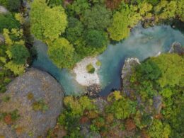
The Kouvaras Gorge is an impressive geological formation approximately 5 km long, separating the two settlements of Dolo and Pogoniani. The gorge is rich in diverse vegetation, featuring oaks, ash trees, hornbeams, maples, wild cherries, wild almond trees, both wild and cultivated figs, chestnuts, plane trees, and willows. The dense and varied plant life, along with rock openings, provides a safe nesting and feeding habitat, particularly for birds of prey. It serves as an important habitat for rare bird species.
The Kouvaras Gorge is an impressive geological formation approximately 5 km long, separating the two settlements of Dolo and Pogoniani. The gorge is home to a diverse range of vegetation, including oaks, ash trees, hornbeams, maples, wild cherry trees, wild almond trees, wild and cultivated figs, chestnuts, plane trees, and willows. The dense and varied plant life, along with rock openings, provides a safe nesting and feeding area, especially for birds of prey. It is an important habitat for rare bird species.